What is the Best Route to Reach Umling La?
- Brahmand Tour
- Aug 8, 2025
- 3 min read

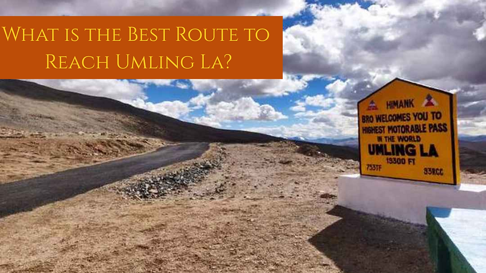
You’ve probably heard of Khardung La or maybe even Chang La, but Umling La, the Highest Motorable Pass in the World at 19,024 feet, is in a league of its own. That’s higher than Everest Base Camp. Higher than Mount Elbrus in Russia. Higher than any civilian airstrip on Earth. The oxygen level drops to nearly 50 percent. So even walking for a few minutes at the pass feels like sprinting up ten floors without a break.
Most people think the toughest part is the high altitude. That’s not entirely true. The altitude is just one layer of the challenge. What really tests you is the combination of low oxygen, rapid weather changes, high UV exposure, loose gravel trails, frozen stream crossings and almost zero vehicle support.
There is no fuel station for over 250 km. There is no food outlet after Hanle. There is no hospital if your oxygen levels crash. Your phone network will go out before you reach the final ascent. To cover this amazing Journey, here are the best routes that you can follow and reach here easily:
Route 1:
Hanle via Punguk - Ukdungle - Nurbu La - Chisumle Bridge - Umling La (88 km)
This is one of the more stable routes in terms of terrain. The road is wider most of the time and the inclination is gradual. I would drive during mid-morning when there’s no snow and the temperature is moderate.
Route 2:
Hanle to Umling La via Bogge/Zursur - Nurbu La Top - Chisumle Bridge - Umling La (72 km)
This route is one of the shortest and most common. The road is relatively wider most of the time and the inclination is gradual. It’s ideal if you drive during mid-morning when there’s no snow and the temperature is moderate. Bogge and Zursur have barely any civilian presence and no stopover facilities. The weather becomes unpredictable in the upper stretches after Zursur.
Route 3:
Hanle - Bogge - Beyond Nurbu La Top - Chisumle Bridge - Umling La (62 km)
It’s the shortest among all six. You might think that’s the best, but wait. Terrain is raw and exposed. If there’s snow or even light rain, this route becomes risky. There are some deep gravel stretches just before Chisumle Bridge.
Route 4:
Hanle - Photi La - Photile - Chisumle - Chisumle Bridge - Umling La (75 km)
If you want a more scenic and less isolated drive, this might be the one for you. Photi La Pass has some amazing high altitude desert terrain. But it’s prone to landslides and loose rocks, especially after Photile.
Route 5:
Loma Bridge - Dungti - Fukche - Koyul - Lekeng Yok - Chisumle - Chisumle Bridge - Umling La (116 km)
This route is longer and has more military checkpoints. That can be a double edged sword. On one hand, you have more help available if something goes wrong. On the other hand, it slows you down as document checks are strict and time consuming.
Route 6:
Loma Bridge - Dungti - Fukche - Koyul - Demchok - Umling La (129 km)
This is the longest and most sensitive route. Demchok is very close to the Indo-China border and is heavily monitored by the Indian Army. You need special permissions and sometimes even that is not enough depending on the situation.
Check Out: A Detailed Guide for Umling La Pass
Conclusion
Umling La Pass is the ultimate test for adventure enthusiasts, offering awe-inspiring views and extreme challenges at 19,024 feet. Careful planning, acclimatisation, and a reliable vehicle are essential for a safe journey. Whether you are riding solo or joining a Motorbike Tour in India, this route promises an unforgettable experience for those ready to conquer the world's highest motorable pass.

Comments